There are loads of websites that allow you to plot a route and assess the climbs, the one I used above was the Garmin Course Creator which is simple to use
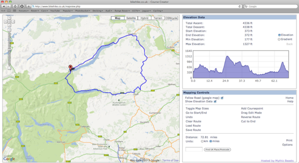
Another is bikehike.co.uk (see below) which is excellent. Have a play around with it and see what's in your area
It was freezing when I headed out for today's ride. Left the house and went to visit a mate in Stirling, 40 miles there via Lennoxtown, Campsie Glen (5 Cat 4 climbs and 3 Cat 3 climbs), Fintry and Kippen. Lunch and a chat and home via Denny, Kilsyth, Kirkintillock and Bishopbriggs.
Total of 74.56 miles and elevation gain of 4114 feet with my biggest climb of the day being 1112 feet and I managed to burn off some 2300 calories
great effort, that chap! fintry, the carron valley etc was my main training ground when i lived in glasgow - pretty dreadful roads mostly but great routes. will attempt the crow road at some point this year - i honestly can't remember when i last did it. still the worst climb for me was the tak ma doon road up from kilsyth to the carron valley - horrible!!!
You two really should pop into the MacRetro road riding thread now and again. Its quite low key compared to the mountain bike stuff but there are rides every so often
My plan yesterday was to come back to Glasgow via Tak Ma Doon Road, but I made a complete mess of my route plan on Garmin and instead of checking the route properly before heading out I only found I had put in the wrong details when en-route, therefore missed it out completely. It looks like a steeper climb from the Stirling side but not as long drawn out, so I am now planning another route, Glasgow, Crow Road, Fintry, B818 to the Tak Ma Doon Road, then down to Kilsyth and back to Glasgow. 42 Miles from the Trongate and some nice elevation work of two 1000+ feet climbs.
If anyone is up for it we could have a retrobike run although I must admit I won't be using the Alan or Peugeot for this as the gearing is way too high.
You two really should pop into the MacRetro road riding thread now and again. Its quite low key compared to the mountain bike stuff but there are rides every so often
i don't know if you've done the tak before or not but it's wayyy easier from the stirling
side than the kilsyth side, which is quite brutal towards the top. :shock:
i can't say i blame you for taking the "jessie" bike instead!! i'm going to look for one for myself as the winter is looming and don't want to waste my battered old eddy merckx to the council's salting programme when it inevitably strikes!


")

