gps systems!!! confused!! advice please!

jonnyboy666

Moderator
Retrobike Rider
Gold Trader
Feedback
View
need a gps system, absolute spaz with technology! so simple is best! :D like me!

been on the garmin site and have spoken to them at shows but no-one ever seems to answer the questions i have! they just tell me what the features are without explaining what they do for me! :?

basically i don't give a monkey's left bollock about the usual bike functions as i have a speedo for that, but if it has them then so be it, all i want is a gps that tells me what direction to go in after i have downloaded a route in to it.

this way i can go to unknown places and ride without fear of getting totally lost! It has happened before! :D too many times!

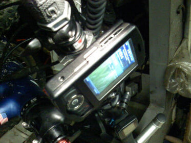
i would like if poss for the display to be in colour but it's not essential, what i'd like to see is a map display with my position on it and an arrow as a direction pointer or something like that.

main reason is i'm planning a week off and want to do a tour of places i haven't been to.

any help would be greatly appreciated!!!

thank you gents in advance
 
A good mate of mine has a Garmin, I'm going to say it's a 605 going by their website but I can't say for sure. He downloaded the maps onto it and proudly navigates his way around the route.

In short, he loves it.

I think the maps were extra - I have a feeling he ended up paying quite a bit of cash for them.

Personally, I'd buy a couple of OS maps but then I love maps and will happily pore over them for hours looking for new trails and new ways to join existing ones together.

Having said that, I can see the attraction of recording your route on a little gadget so you can plot where you've been. I've heard good things about the wrist-based ones now - you can even get little maps on the Garmin forerunner I think

Sorry, not much help ....
 
any help is good! main reason i can't do maps is coz if i don't know the area i'm going to i won't know on a map what will be a route or not! besides i'm not only crap with computers it's maps aswell, i usually find routes just by exploring or going to places like affan etc. but i want to do something different, explore north!! :D

i ride on the isle of wight quite alot and thought i knew it well then i went on a ride with some mates following one of their gps systems and it showed us loads of new trails i'd never seen before that he'd downloaded for that days ride but i can't get hold of that guy to ask what his gps was though! i know it was a garmin but not which one! :x
 
I just called Rich and he's got a Garmin Etrex Vista

http://www.pocketgpsworld.com/garminetrexvista.php

but he says they've now bought out a Vista HCx with a colour screen and dropped the price

https://buy.garmin.com/shop/shop.do?cID=145&pID=8703 which has better reception in trees.

The mapping package he bought was the Ordnance Survey Topo GB of the British Isles, costing about £150 showing footpaths, petrol stations, shops etc which he find pretty useful especially when in an unknown area
 
nokia n82 :) chuck away(or sell) your phone,camera,ipod,gps and reciever and replace it all with one bit of incredible kit :)
 
The Garmin 'x' models have a SD card slot on the top for maps. Whereas the non'x'

I would have said you should avoid a serial port GPS because they are annoying to download and upload the routes. Get a USB one. Some of the Garmin models come with a handlebar clip. However the Forerunners come with a strap for your arm/wrist.
 
Garmin Edge 205/305/605 - there might be some others too. Forerunner is good, big wrist watchy thing.

Edge 305

What you're after is a mapping unit. Colour or B&W, you download your maps onto the unit and follow your pointer on the screen.

If you buy Memory Map software, planning your route is a snap - just download to your GPS and off you go. On the other side of the coin, anywhere you ride can be recorded via your GPS, uploaded as a tracklog to Memory Map on your laptop or pc and saved as a future route. You can also 'fly' the route via the software - neat!!

If you buy a non mapping unit, you'll get your directions as vectors on the screen with a pointer to follow. You'll still need a map ideally, but if you have the Memory Map software, you can plot your route, print out a map with just YOUR route on it (for cross reference) and follow the vectors on screen, referring to your back up map (A4 sheet) if you need to. You can still download your plotted route to your non-mapping GPS unit and upload the tracklogs.

The Edge models are good cycling specific units and offer other functions as well - HRM, cadence, crank speed and the usual performance orientated stuff.

I want one!! Amazon.co.uk do the Edge 205 from £100 and the 305 from £162.

There's a wealth of extras available - USB cables, serial cables, extra antennae, etc.
 

Latest posts

Back
Top